A massive and fast-moving winter storm is sweeping across the United States this week, bringing a dangerous mix of heavy snow, rapidly plunging temperatures, and fierce winds that could disrupt daily life for millions of Americans. According to fresh guidance from the National Weather Service (NWS), certain states are preparing for up to 14 inches of snow through December 10, with hazardous travel conditions likely from early morning commutes into the late evening hours as roads freeze over. The widespread alerts have created a growing sense of urgency, especially as this system is unusually large and capable of affecting multiple regions simultaneously, stretching from the Northern Rockies all the way into the Mid-Atlantic. For many areas, the timing of the storm colliding with peak travel periods is expected to make its impact even more disruptive.
Table of Contents
States Expected to See the Heaviest Snowfall and Strongest Winds
Snowfall predictions vary widely by region, but several states face significant accumulation and wind risks. According to the NWS, areas within Wyoming, Montana, Michigan, Tennessee, Kentucky, Washington, North Carolina, Virginia, and Illinois are among the most likely to see intense snowfall, especially higher-elevation zones and lake-effect corridors. The storm’s strongest impact is expected across Wyoming’s Absaroka and Beartooth Mountains, where snow totals could reach two feet, accompanied by wind gusts approaching 70 mph, creating dangerous whiteout conditions that make even short trips risky. Meanwhile, Michigan’s west side is preparing for 8 inches of lake-effect snow, which can intensify with little warning. Illinois, particularly Lake and northern Cook counties, is expecting 3 to 4 inches, with the heaviest snow forming overnight as temperatures fall sharply below freezing.
Projected Snowfall and Hazard Overview
| Region / State | Expected Snowfall | Additional Hazards |
|---|---|---|
| WY & MT (Absaroka & Beartooth) | 18-24 inches | 70 mph winds, whiteouts |
| West Michigan | 6-8 inches | Heavy lake-effect bands |
| Northern Illinois | 3-4 inches | Overnight ice formation |
| Tennessee / Kentucky | 4-8 inches | Slippery highways |
| Washington / North Idaho | 5-10 inches | Rain + snow mix |
| Interior Alaska | 6-12 inches | Blowing snow |
Data sourced from current NWS regional advisories.
Why This Storm Poses a Serious Safety Risk
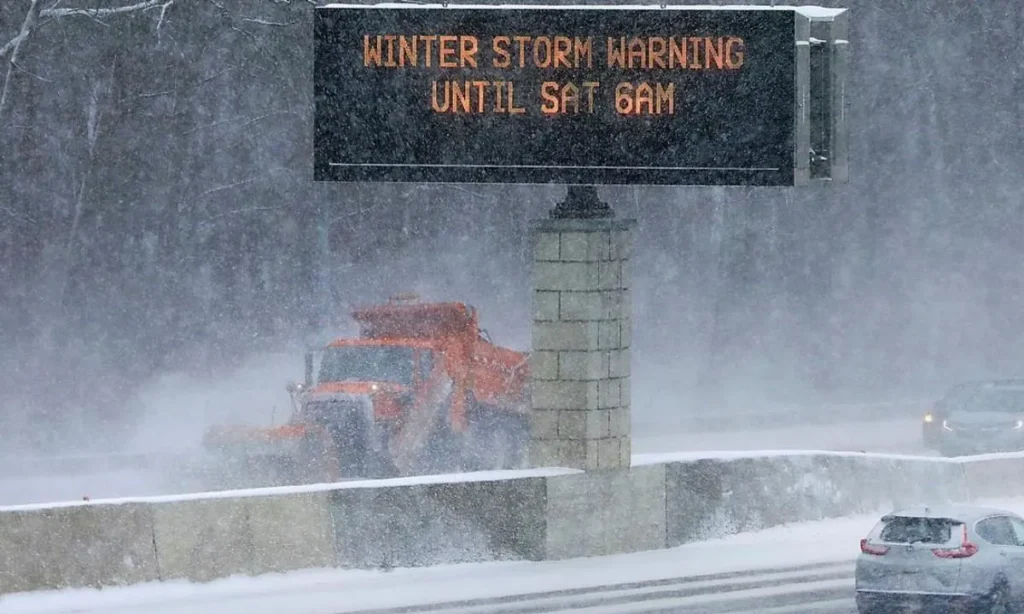
Winter storms are often unpredictable, but the dangers associated with this system are amplified because of the temperature swings and the combination of snow, sleet, and freezing rain. The AAA Foundation for Traffic Safety reports that winter weather contributes to nearly 500,000 crashes and over 2,000 deaths every winter season. With this storm, experts warn that even experienced drivers may face sudden hazards, especially as strong winds and blowing snow reduce visibility and create black ice within minutes. The rapid cooldown expected at night means roads that appear wet may turn slick without warning, particularly on bridges, shaded sections of highways, and rural routes. AAA encourages Americans to postpone non-essential travel, charge phones fully before heading out, and ensure their vehicles have blankets, water, and winter emergency kits in case of delays.
What You Must Know Before Traveling
- Drivers should slow down significantly and avoid sudden braking, which increases the risk of skidding on icy surfaces.
- Keeping your fuel tank at least half full is recommended to prevent fuel line freeze and ensure you have heat if stuck in delays.
- Visibility may drop quickly, so if conditions worsen, safely pull off the road rather than attempting to continue through heavy snow or blowing wind.
Atmospheric River Adds a Second Major Threat to the West Coast
While the central and eastern U.S. brace for major snow, the Pacific Northwest is preparing for something entirely different a strong atmospheric river that could deliver flooding rain, powerful gusts, and rapidly rising streams. The NOAA describes atmospheric rivers as narrow “rivers in the sky” capable of transporting huge volumes of water vapor over thousands of miles. When these systems make landfall, they can unleash relentless rainfall that overwhelms drainage systems and flood-prone neighborhoods. Washington, Oregon, Idaho, and parts of Montana are under multiple alerts as the moisture surge intensifies. Meteorologists warn that rainfall coverage will increase through mid-week, raising the likelihood of flash flooding, mudslides, and travel disruptions. Coastal zones may also face rough seas and minor coastal flooding, especially during high tide cycles. For many communities, this means preparing not only for heavy rainfall but also for power outages and fallen trees due to saturated soil and strong gusts.
What Officials Are Urging Residents to Do Now
Federal forecasters at the NWS emphasize the importance of keeping an eye on updated weather alerts, as conditions may shift quickly. Emergency management agencies are recommending that residents prepare supplies, avoid unnecessary travel, and check in on vulnerable neighbors or elderly family members who may need assistance during prolonged weather impacts.
FAQs
- How long will the winter storm last?
Most regions will see impacts from Dec 8-10, but lingering snow showers and icy roads may continue beyond that depending on temperatures.
- Which area will be hit the hardest?
Wyoming and Montana’s mountain regions expect the most extreme snowfall up to two feet with 70 mph winds.
- What is an atmospheric river?
It is a long, narrow band of concentrated moisture in the atmosphere capable of producing heavy rainfall and flooding when it moves inland.
- Is travel safe during this storm?
Travel is strongly discouraged during peak snowfall and overnight hours when ice forms quickly.
- Where can I check official updates?
NWS Alerts: https://www.weather.gov
NOAA River Forecasts: https://www.noaa.gov
AAA Safety Tips: https://www.aaa.com